 Antiques (CA)
Africa Maps
Asia Maps
Australia/Oceania Maps
Celestial Maps
Central America/Caribbean Maps
Curiosities Maps
Digital Maps
Europe Maps
Map & Globe Mixed Lots
Map & Globe Reproductions
North America Maps
South America Maps
World & Celestial Globes
World Maps

-
$130.29 CAD

 Antique MAP RIVERTON & NAPONEE/Atlas of Franklin Co. Nebraska - Ogle & Co. 1923
-
$274.22 CAD
 Original 1923 Boone County Illinois IL Atlas by Ogle & Co Plat Book
-
$1218.18 CAD
 1929 OFFICIAL REAL ESTATE ATLAS CITY OF DETROIT HEARNE BROTHERS LARGE RARE BOOK
-
$87.43 CAD
 Winston’s new and complete atlas of the world 1921
-
$274.28 CAD
 La Salle County Illinois Antique ATLAS & Plat Book Hand Colored Maps 1929
-
$26.06 CAD
 1921 Literary Digest Atlas of New Europe and The Far East
-
$239.94 CAD
 Original 1920 Schuyler County Illinois IL Atlas by Kenyon Co Plat Book
-
$17.83 CAD
 The literary digest 1929 atlas of the world and gazetteer
-
$102.79 CAD
 Original 1923 Boone County Illinois IL Atlas by Ogle & Co Plat Book
-
$308.58 CAD
 RARE 1929 Paved Road Atlas George F. Cram Co. USA Canada Maps Item-Tribune Vtg
-
$61.65 CAD
 Rare Rochester NY + Suburbs Large Planning District Map Book Atlas 1922 ?racist?
-
$96.00 CAD
 ANTIQUE Maps EUROPE historical ATLAS coinage BATTLES Literature GAZETTEER 1920s
-
$16.27 CAD
 1920 Color Maps Political Features of France (no explanation of the colors!) Map
-
$198.86 CAD
 Antique MAP OF THE WORLD - Atlas Of GRAND FORKS CO. N. DAKOTA - Ogle & Co. 1927
-
$287.04 CAD
 1920s Philadelphia Suburban Atlas Directory Main Line Real Estate Map
-
$130.29 CAD
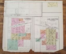 Antique MAP CAMPBELL & HILDRETH/Atlas of Franklin Co. Nebraska - Ogle & Co. 1923
-
$34.97 CAD
 Antique 1920s 1921 Cleveland Ohio City Street Map from Atlas
-
$6.69 CAD
 EASTERN HEMISPHERE Rand Mcnally & Co 1927 Map Print 14" x 11" Premier Edition
-
$34.97 CAD
 Antique 1921 Detroit Michigan City Street Map from Atlas
-
$2742.90 CAD
 PRINCETON, NJ - SANBORN INSURANCE MAPS & FRANKLIN SURVEY ATLAS Two Vol's 1927-30
-
$16.27 CAD
 1920 Color Maps Physical Indian Empire + Farther India and the East Indies Map
-
$16.46 CAD
 1920 OGLE PLAT ATLAS OF SALINE COUNTY, KANSAS-MAP OF SPRING CREEK TOWNSHIP
-
$137.15 CAD
 1920s PRESIDENTIAL WALL ATLAS 6 Sides World Leaders First Ladies Radio Stations
-
$29.50 CAD
 Old 1927 Pictorial Map ~ SAVOIE - DAUPHINE Province, FRANCE by J.P. Pinchon
-
$16.27 CAD
 1920 Color Maps of Railways of Great Britain and Geological Rainfall & Tides Map
-
$48.00 CAD
 1924 atlas of the world and gazetteer
-
$960.00 CAD
 1929 V2 Brooklyn ~400 MAPS ALL WILLIAMSBURG Greenpoint East New York Brownsville
-
$24.69 CAD
 1925 VINTAGE HISTORICAL MAP OF ANCIENT WORLD / PTOLEMY MEDICI-LAURENTIAN ATLAS
-
$102.86 CAD
 1920 Main Line Atlas - Pennsylvania RR - NARBERTH/MERION TOWNSHIP
-
$102.86 CAD
 Antique MAP - JOHNSTOWN TOWNSHIP-Atlas GRAND FORKS CO. N. DAKOTA/Ogle & Co. 1927
-
$29.14 CAD
 a literary and historical atlas of europe 1923 Bartholomew
-
$205.72 CAD
 Antique MAP EAST GRAND FORKS - Atlas Of NORTH DAKOTA - Ogle & Co. 1927
-
$16.27 CAD
 1920 Color Maps by John Bartholomew of Physical Europe Map
-
$1234.29 CAD
 1929 Hyde Atlas V.1 200 Maps Brooklyn HEIGHTS CROWN PROSPECT PARK SLOPE DUMBO ++
-
$34.97 CAD
 Antique 1920s 1921 Pittsburgh Pennsylvania City Street Map from Atlas
-
$20.57 CAD
 OFFICIAL MAPS OF NEW ENGLAND - National Survey Co Chester VT - 96 pgs complete
-
$36.66 CAD
 1928 Map Philadelphia 36 Ward Moore Morris Tasker Dickinson Point Breeze Watkins
-
$411.42 CAD
 1929 V.3 Brooklyn 200+ MAPS BAY RIDGE BENSONHURST FLATBUSH BORO PARK KENSINGTON
-
$198.86 CAD
 Antique MAP OF NEBRASKA - Atlas Of Franklin County Nebraska - Ogle & Co. 1923
-
$34.97 CAD
 the literary digest atlas of the world and gazetteer 1927
-
$13.71 CAD
 1920 ANTIQUE OGLE PLAT ATLAS OF SALINE COUNTY, KANSAS-MAP OF FALUN TOWNSHIP
-
$6.69 CAD
 WYOMING / WISCONSIN, Rand Mcnally & Co 1927 Map Print 14" x 11" Premier Edition
-
$19.01 CAD
 1920 Color Maps Physical/Political Italy Yugo Slavia and Balkans 2X pages Map
-
$19.01 CAD
 1920 Color Maps Physical Africa and British South Africa Map
-
$37.23 CAD
 1927 Pictorial Map ~ AUNIS - SAINTONGE - POITOU Prov., FRANCE by JP Pinchon
-
$29.50 CAD
 1927 Pictorial Map ~ NORMANDY PROVINCE, FRANCE ~ Illustrated by J.P. Pinchon
-
$44.20 CAD
 1928 Map Philadelphia 36 Ward Lanier Park Tasker Morris Dickson St Gabriel's
-
$34.97 CAD
 Antique Vintage 1920s Denver Colorado City Street Map from Atlas 1921
-
$17.81 CAD
 Map of 1715-1789 Europe from 1924 edition,Dutch school atlas.
-
$487.55 CAD
 Vintage 1927 FRANKLIN MASSACHUSETTS Sanborn Insurance MAPS Atlas - DEAN College
-
$29.14 CAD
 the literary digest historical and political atlas of new europe 1921
-
$123.36 CAD
 1927 antique ROAD ATLAS thos cooke AUTO ROUTE DISTANCE ATLAS ne ny nj pa md de
-
$13.65 CAD
 1923 Original Antique Hammond Map: Cuba and on reverse Porto Rico
-
$34.29 CAD
 The Official Maps of New England L. Crocker Topographer, National Survey Co.
-
$63.02 CAD
 Antique German Book Knaurs Welt-Atlas 1928 Colored Maps Dr Johannes Riedel
-
$54.84 CAD
 antique 1926 Rand McNally Premier Atlas of the World
-
$34.92 CAD
 Antique General Pershing's Battle Map American Sector WWI from 1921 Atlas
-
$16.27 CAD
 1920 Comparative Atlas by John Bartholomew Color Maps of Astronomical Geography
-
$19.01 CAD
 1920 Color Maps Political United States and Physical South America Map
-
$10.96 CAD
 National Geographic 1925 Map Of Washington DC. Approx 13 By 17 Inches. Frameable
-
$29.06 CAD
 Antique 1921 Baltimore Maryland City Street Map from Atlas
-
$822.86 CAD
 1929 V.4 Brooklyn 260 maps! CONEY ISLAND SHEEPSHEAD FLATLANDS CANARSIE MIDWOOD
-
$30.17 CAD
 Tasmania, New Guinea Fiji, Samoa & NZ - Large Original 1926 Map by George Philip
-
$19.01 CAD
 1920 Color Maps Physical Features of Ireland and Scotland Map
-
$34.97 CAD
 Antique 1921 Memphis Tennessee City Street Map from Atlas
-
$19.01 CAD
 1920 Color Maps Physical/Political Features Russia Finland Sweden Norway Denmark
-
$66.45 CAD
 Rand McNally Antique World Atlas Commonwealth Edition 1928 Vintage Maps Globe
-
$6.69 CAD
 S. CAROLINA / R. ISLAND Rand Mcnally & Co 1927 Map Print 14" x 11" Prem. Edition
-
$19.01 CAD
 1920 Color Maps Physical Dominion of Canada and Political North America Map
-
$29.50 CAD
 Old 1927 Pictorial Map ~ MAINE - ANJOU - TOURAINE Prov., FRANCE by J.P. Pinchon
-
$56.96 CAD
 1928 Map Philadelphia RARE -26 36 & 48 Ward Index Hand Colored Schuylkill River
-
$34.63 CAD
 1928 Map Philly Schuylkill East Railroad Grays Ferry Wharton Dupont De Nemours
-
$26.72 CAD
 Map of Japan from the 1920 Times Survey Atlas; inset maps of Tokyo and Nagasaki
-
$30.16 CAD
 Antique New Mexico and New Jersey Map from Atlas 1920s 1921
-
$17.81 CAD
 Map of 1660-1715 Europe from 1924 edition,Dutch school atlas.
-
$29.50 CAD
 1927 Pictorial Map ~ ILE-DE-FRANCE Prov., FRANCE ~ Illustrated by J.P. Pinchon
-
$6.69 CAD
 ASIA CHINA Rand Mcnally & Co 1927 Map Print 14"x11" Premier Edition
-
$29.50 CAD
 1927 Pictorial Map ~ FLANDRE - ARTOIS - PICARDIE PROV., FRANCE by JP Pinchon
-
$343.16 CAD
 MAP 1922 CRAM’S HOME LIBRARY ATLAS WWI SYNOPSIS
-
$28.36 CAD
 Original 1929 Pictorial Map by L. Price ~ " FATHER ATLAS - VOLCANOES "
-
$69.94 CAD
 complete handy atlas of the world 1920?
-
$19.01 CAD
 1920 Color Maps Political South America + Mexico Central America West Indies Map
-
$137.15 CAD
 Atlas of Marshall County Iowa 1924 Book plus Hammond's Atlas of the World 1914
-
$29.50 CAD
 Old 1927 Pictorial Map ~ LORRAINE Province, FRANCE Illustrated by J.P. Pinchon
-
$29.06 CAD
 Antique Minneapolis St Paul Street Map from Atlas 1920s 1921
-
$6.69 CAD
 MEXICO YUKON Rand Mcnally & Co 1927 Map Print 14"x11" Premier Edition
-
$29.50 CAD
 Old 1927 Pictorial Map ~ GASCOGNE - BEARN Prov., FRANCE Illus. by J.P. Pinchon
-
$23.31 CAD
 Southern India & Ceylon - Original 1924 German Language Map by Meyers. Vintage
-
$29.50 CAD
 Old 1927 Pictorial Map ~ LANGUEDOC - ROUSSILLON - FOI Prov., FRANCE JP. Pinchon
-
$27.43 CAD
 1925 Rand McNally Atlas of America NEWYORK /21"x29" Adjoining New Jersey Towns
-
$16.27 CAD
 1920 Maps by John Bartholomew of Jan/July Rainfall &Winds Races & Religion Map
-
$16.27 CAD
 1920 Color Maps Physical Features of Switzerland and the Alps Map
-
$29.50 CAD
 Old 1927 Pictorial Map ~ ORLEANAIS - BERRY Prov., FRANCE Illus. by J.P. Pinchon
-
$205.72 CAD
 1927 Rand Mcnally World Atlas Premier Edition
-
$20.57 CAD
 Antique Arizona from Atlas 1920s 1921
-
$37.23 CAD
 Vtg Lot 1923 WAUPACA Co. WISCONSIN Illustrations, Land Owners, Homes & Buildings
-
$19.01 CAD
 1920 Color Maps Density of Population Greater Britain Map
-
$37.23 CAD
 1927 Pictorial Map ~ MAINE - ANJOU - TOURAINE Prov., FRANCE by J.P. Pinchon
-
$68.57 CAD
 Antique Illust. (FARMS/HOMES) Atlas of Grand Forks, N. Dakota/Ogle & Co 1927
-
$198.86 CAD
 Antique MAP OF THE UNITED STATES - Atlas Of Harlan Co. Nebraska - Ogle & Co 1921


