 Antiques (CA)
-
$82.22 CAD

 1916 UNITED STATES Map ORIGINAL LARGE Wisconsin Indiana Pennsylvania Delaware
-
$34.33 CAD
 1911 Map NORTH DAKOTA Indian Reservation Fort Berthold
-
$205.95 CAD
 Antique 1920 Standard Atlas Of Saline County, Kansas
-
$205.95 CAD
 Antique 1917 Standard Atlas Of Smith County, Kansas
-
$8.93 CAD
 Map: Vermont & New Hampshire - 1910 county boundaries, railways, cities - sepia
-
$13.39 CAD
 1910 Antique Color Map of The World 17" x 27"
-
$17.78 CAD
 1914 Vintage IDAHO Railroad Map Wall Art Decor Old Original Boise Antique
-
$24.03 CAD
 Antique 1914 Map Of Part Of New York Borough Of Kings (Brooklyn) 11x15 Inches
-
$20.60 CAD
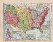 1911 ANTIQUE RAND MCNALLY NEW IDEAL ATLAS MAP-UNITED STATES EXPANSION
-
$30.89 CAD
 1912 Antique Arizona State Map Vintage Map of Arizona Gallery Wall Decor 1586
-
$48.04 CAD
 Vintage Color Folio Geologic Atlases of the United States, 1894 - 1945 PICK ONE!
-
$645.36 CAD
 USGS geology of Lake Superior Region Spectacular many Maps and color plates 1911
-
$39.49 CAD
 Vintage 1912 OKLAHOMA Map 22"x14" ~ Old Antique Original GUTHRIE STILLWATER OK
-
$26.78 CAD
 Antique 1914 Map Of Milwaukee Wisconsin 11x15 Inches
-
$30.99 CAD
 1912 ORIGINAL ANTIQUE MAP OF MEXICO / YUCATAN / BAJA CALIFORNIA / TEXAS
-
$27.45 CAD
 USGS Topographic Map Pittsville Maryland Antique Original 1914 16x20
-
$82.32 CAD
 Antique 1912 Book: 'The Library Atlas of the World' Vol. II Foreign Countries
-
$26.78 CAD
 Antique Map 1914 City Of Pittsburgh PA 11x15 Inches
-
$24.72 CAD
 Oklahoma - Original 1911 Dated Map by Dodd Mead & Company. Antique
-
$24.10 CAD
 1911 Antique Map of Idaho State Map of Idaho Gallery Wall Decor smap 1176
-
$39.13 CAD
 1910 Plat Map New Lenox Township Will County Illinois Marley Spencer Original
-
$17.78 CAD
 Vintage MISSISSIPPI Map State Wall Art Decor Jackson Hattiesburg Antique
-
$80.31 CAD
 1917 New York The Century Co THE ADIRONDACKS THOMAS T. MORRIS LONSTRETH NY Maps
-
$37.03 CAD
 MN 1911 MINNESOTA RAILROAD Wall Map SOO MINNEAPOLIS St PAUL & SAULT STE MARIE RR
-
$24.72 CAD
 Nebraska - Original 1910 Dated Map by Dodd Mead & Company. Antique
-
$17.78 CAD
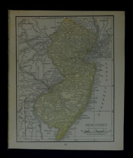 1911 Antique Rand McNally Map of NEW JERSEY w/copy History/Demographics
-
$27.46 CAD
 Alabama - Original 1911 Map by The Century Company. Antique
-
$137.30 CAD
 Antique Original 1917 Standard Atlas Montgomery County Indiana Plat Book
-
$549.24 CAD
 Humboldt National Forest Map proclamation woodrow wilson 1919
-
$137.31 CAD
 Antique MAP-PART 4 OF THE CITY OF KALAMAZOO & ENVIRONS, Michigan/Ogle & Co. 1910
-
$205.90 CAD
 Original Antique Denny’s pocket map of Sutter County, California 1913
-
$24.72 CAD
 Texas & Oklahoma - Original 1911 Map by Dodd Mead & Company. Antique
-
$19.72 CAD
 Antique Small UNITED STATES Map 1911 USA Map of the United States smap 1540
-
$18.54 CAD
 Antique 1914 Map Of Balkan States 11x15 Inches
-
$13.72 CAD
 1917 McNally Map Louisiana New Orleans Baton Rouge Lake Charles Pontchartrain LA
-
$26.78 CAD
 Antique Map 1914 City Of Philadelphia Pennsylvania 11x15 Inches
-
$27.39 CAD
 CENTURY ATLAS MAP PLATE #48 "OKLAHOMA" CITY TULSA CHEROKEE ORIG ANTIQUE 1911 OK
-
$28.51 CAD
 1912 ANTIQUE MAP OF MEXICO / VERSO VICINITY OF MEXICO CITY
-
$54.76 CAD
 1916 UNITED STATES Map ORIGINAL Rainfall Colorado Montana Michigan Wisconsin
-
$13.66 CAD
 1911 Original Antique Hammond Atlas Map of Utah on reverse Idaho
-
$39.13 CAD
 1910 Plat Map Frankfort Township Will County Illinois Mokena Original
-
$16.28 CAD
 1917 Vintage CLEVELAND Map City Street Old Original Cleveland Ohio Antique Road
-
$500.00 CAD
 Very large 1913 Manitoba Map 3’5” X 2’8”
-
$24.70 CAD
 Earliest AAA Road Map New England 1911
-
$63.09 CAD
 1910 Plat Map MINER, CIRCLEVILLE, WINKEL, LILLY, TAZEWELL Co., IL (XL17x29)-#020
-
$26.78 CAD
 1916 Plat Map Woodland Woodlawn Fine Lake Barry County Detroit Michigan Original
-
$19.91 CAD
 1912 Map State of Minnesota Original Color 15" x 23"
-
$24.65 CAD
 1660 Castello Plan New Amsterdam Historic Vintage Style Wall Map - 20x28
-
$68.64 CAD
 RARE THE OFFICIAL MAP OF THE WORLD NATIONAL SURVEY CO 1919 SPHERICAL VIEW
-
$39.13 CAD
 1910 Plat Map Town of Frankfort Will County Illinois Stillwagon Bowen Otter
-
$13.73 CAD
 1910 OGLE PLAT ATLAS OF WAYNE COUNTY, ILLINOIS-MAP OF UNITED STATES-MERIDIANS
-
$26.78 CAD
 Antique 1914 Map Of Louisville Kentucky 11x15 Inches
-
$17.78 CAD
 Vintage PORTLAND City Map Oregon Wall Art Old Original Decor DATED 1911
-
$13.72 CAD
 Wisconsin, Grant County 1918 Plat Map Towns/ Clifton Lima Potosi village
-
$27.45 CAD
 Original 1915 Plat Map Village of Cedar Creek Wis WI Polk Bibingers Slinger
-
$26.78 CAD
 Antique 1914 Map Of Cincinnati 11x15 Inches
-
$24.10 CAD
 1917 Antique Alabama State Map Vintage Atlas Map of Alabama Wall Decor 1254
-
$24.03 CAD
 1916 Plat Map Gun Lake Wall Crooked Pine Barry County Detroit Michigan Original
-
$17.78 CAD
 1911 Antique Rand McNally Map of MAINE w/copy History/Demographics
-
$48.20 CAD
 1914 ORIGINAL ANTIQUE MAP OF SAN FRANCISCO SAN JOSE AND VICINITY / CALIFORNIA
-
$26.78 CAD
 Antique 1914 Map Of Buffalo New York 11x15 Inches
-
$226.40 CAD
 1916 INWOOD MANHATTAN NEW YORK CITY NY Land Street Map INWOOD HILL PARK ON BACK!
-
$82.39 CAD
 1914 Rand McNally Montana Large Color Folding Map & Guide Highways Railroads
-
$196.35 CAD
 Standard Atlas of Lanawee County Michigan 1916, Large Folio, E-80
-
$20.56 CAD
 1916 NY State Wall Map. Soft Pastels. 19x12. 1910s New York Map Art Print Decor
-
$137.30 CAD
 Ashland Bayfield Wisconsin WI Wis County Fold Out Maps 1917 ABSOLUTELY BEAUTIFUL
-
$61.79 CAD
 Lot 10 Different Vintage USGS Washington State Topographic Maps 1910-50's 2
-
$24.72 CAD
 Connecticut - Original 1910 Dated Map by Dodd Mead & Company. Antique
-
$39.13 CAD
 1914 Antique Color Map of Sangamon County Illinois
-
$41.96 CAD
 1912 ANTIQUE MAP OF EASTERN USA GREAT LAKES NEW YORK / VERSO CITY MAP OF CHICAGO
-
$17.78 CAD
 1914 Vintage MONTANA State Map Antique Map of Montana Wall Art Home Decor
-
$42.44 CAD
 1910 Plat Map ~ ARMINGTON, TAZEWELL Co., ILLINOIS (9.5x17)-#029
-
$9.89 CAD
 1910 Antique SOUTH CAROLINA Map Vintage State Map Gallery Wall Art
-
$26.78 CAD
 1914 Plat Map Village of Loami Sangamon County Illinois
-
$17.78 CAD
 Vintage TENNESSEE Map Wall Art Decor Original Antique ca 1912 Nashville Memphis
-
$21.97 CAD
 1919 Antique RR Map Atchison Topeka Santa Fe Railroad System KC to San Francisco
-
$17.78 CAD
 Vintage ALABAMA Map Railroad Wall Art Decor Old Original Antique DATED 1914
-
$63.09 CAD
 1912 Plat Map ~ BARRY, NEW CANTON, EL DARA, PIKE Co., IL (17x29)-#029
-
$9.54 CAD
 Vintage Hammonds 1911 Atlas Map Of Louisiana
-
$27.46 CAD
 Vintage 1913 USGS Topo Map San Jose California 16.5 X 20"
-
$24.10 CAD
 1917 Antique Map of GEORGIA Vintage Georgia State Map Gallery Wall Decor 1226
-
$30.89 CAD
 1915 Antique Color Map of The World Geo. F. Cram
-
$8.24 CAD
 1915 Plat Map Lake Five Richfield Wisconsin WI Township Koch Bros. Hotel Saloon
-
$72.76 CAD
 Hammonds Atlas Of New York City 1915
-
$27.39 CAD
 1918 Tulsa Oklahoma Vintage Old Panoramic City Map - 18x36
-
$39.13 CAD
 1910 Plat Map Du Page Township Will County Illinois DuPage River Goose Lake
-
$24.65 CAD
 1916 Antique Map of The World Original Color Ocean Currents & Routes Railroads
-
$275.83 CAD
 Antique 1916 ST GABRIELS PARK MANHATTAN NEW YORK CITY Map ST VARTAN PARK BROMLEY
-
$19.03 CAD
 Antique 1915 Two-Sided Color Map of North Carolina & New York 10" x 15"
-
$30.89 CAD
 1910 State of Illinois Antique Color Map 17" x 27"
-
$19.15 CAD
 1912 Baltimore, Maryland Vintage Old Panoramic City Map - 16x24
-
$42.44 CAD
 1910 Plat Map ~ CLOVERDALE, TAZEWELL Co., ILLINOIS (9.5x17)-#025
-
$24.03 CAD
 1910 Plat Map City of Joliet Illinois Des Plaines River Railroad & McDonough #16
-
$19.91 CAD
 1912 Plat Map Part of White Earth Indian Reservation Clearwater County Minnesota
-
$27.45 CAD
 ANTIQUE 1917 SUFFOLK COUNTY LONG ISLAND NEW YORK YAPHANK SETAUKET STONY BROOK
-
$19.91 CAD
 1912 Map State of The United States Original Color 15" x 23"
-
$24.03 CAD
 1910 Plat Map City of Joliet Illinois Will County Broadway Washington Heights #4
-
$17.45 CAD
 1910 Antique LOUISVILLE City Map Vintage Louisville Kentucky Street Map Wall Art
-
$686.55 CAD
 Chelan National Forest Map Proclamation Woodrow Wilson 1916
-
$27.45 CAD
 Antique Blacksville West Virginia Original USGS Topographic Map 1940


