 Antiques (CA)
Africa Maps
Asia Maps
Australia/Oceania Maps
Celestial Maps
Central America/Caribbean Maps
Curiosities Maps
Digital Maps
Europe Maps
Map & Globe Mixed Lots
Map & Globe Reproductions
North America Maps
South America Maps
World & Celestial Globes
World Maps

-
$410.06 CAD

 Vintage 24 x 36 1916 Linen Backed Map Oakland San Francisco CA H.A. Candrian
-
$46.47 CAD
 Denoyer-Geppert Northern France Belgium The Rhine 1914-19 Wall Map 44x36" H26
-
$264.69 CAD
 Very Rare c1914 “The Far East. Western Powers to 1914” Large Cloth Back Wall Map
-
$24.53 CAD
 1660 Castello Plan New Amsterdam Historic Vintage Style Wall Map - 20x28
-
$676.59 CAD
 1916 antique ELDRIDGE MAP linen backed GLOUCESTER to KENNEBEC RIVER 24.5"x67"
-
$1025.12 CAD
 1916 Color Wall Map GEOLOGY OF CALIFORNIA "Mother Lode" Oil Wells Roads Railways
-
$20.46 CAD
 1916 NY State Wall Map. Soft Pastels. 19x12. 1910s New York Map Art Print Decor
-
$517.62 CAD
 School Wall Map Italy Alps Mediterranean ~ 1915 122x158 Vintage
-
$10.93 CAD
 Topographic Map of Playas Quadrangle, New Mexico - 1918 - US Geological Survey
-
$54.61 CAD
 Antique Map 1914 Clinton County Illinois Topographic canvas 40" x 24" U.S Geo
-
$248.77 CAD
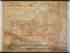 1911 Cram's Superior Map New York, Wall Map, School Map, Original Rollers Rare
-
$977.12 CAD
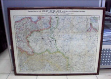
 School Wall Map Nordost-Deutschland 185x178 ~ 1910 Vintage Eastern Germany
-
$61.51 CAD
 1915 DODGE COUNTY Minnesota WALL MAP Mantorville Kasson Hayfield BANK Advertsing
-
$20.50 CAD
 Antique 1913 NY Hamilton County Geological Topography Survey Map 16&1/2"x20"
-
$45.09 CAD
 1919 - 1940 Urbana Illinois IL 34" Historical Political Campaign County 1988 Map
-
$303.66 CAD
 Kieperts Wall Map the German Colonies 1910 122x129 Reichskolonialamt Vintage
-
$36.86 CAD
 MA 1912 DATED MASSACHUSETTS / BOSTON RAILROAD Wall Map. 1910s CHESTER BECKET RR
-
$36.86 CAD
 ME 1912 MAINE RAILROAD Wall Map. BRIDGTON & SACO RIVER RR ; KENNEBEC CENTRAL RR
-
$40.96 CAD
 MN 1909 MINNEAPOLIS ST SAINT PAUL City Wall Map.1900s Map Art Print Decor. MNPLS
-
$38.91 CAD
 MO KS 1911 DATED KANSAS CITY Missouri & Kansas Wall Map. 1910s. Railroads
-
$10.93 CAD
 Topographic Map of Henderson Quadrangle - Kentucky - 1916 - US Geo. Survey
-
$136.69 CAD
 Vintage 1915 Wall Premiere Map of Ohio US WWI Pictures Dirigible Panama Canal
-
$20.50 CAD
 1915 - 1916 Lot of 5 Iowa Lake Maps Duck, Little Wall, Goose, & Silver Lakes
-
$369.77 CAD
 School Wall Map School Map Germany 1815-1914 Reincarnation 197x203
-
$10935.21 CAD
 Wall Map Kingdom Of Prussia From Wilhelm II 80 11/16x52in ~ 1910 Vintage Roll Up
-
$75.18 CAD
 Antique 1904 Topography Map Castine, Maine Penobscot Bay Quadrangle
-
$103.87 CAD
 1913 Maine Wall Map post office routes postal mail canvas backed 48.5 x 38.5"
-
$294.00 CAD
 Wall Map History 81 1/8x66 1/2in ~ 1960 Vintage European Heritage Map~1910-1950
-
$534.42 CAD
 School Wall Map Australia Oceania South Seas 162x138cm ~ 1914 Vintage
-
$602.75 CAD
 School Wall Map Wirtschaftskunde German Rich Vintage 80 5/16x66 7/8in ~ 1919
-
$381.73 CAD
 School Wall Map Old Germany Card 18.Jhd. 198x200cm ~ 1910 Gaebler
-
$651.99 CAD
 Antique Map Old Russia 1914 Empire Rare Frame Cities Boundaries History
-
$231.75 CAD
 Wirtschaft-Wandkarte From Europa 214x157cm ~ 1910 Vintage Economy Wall Map "
-
$279.43 CAD
 School Wall Map Europa~1919 182x160 Vintage Physical Europe School Map After WW1
-
$152.95 CAD
 Wall Map British Islands Höhenprofil 141x137cm Vintage~1915 Sydow-Habenicht
-
$72.43 CAD
 Chadwicks 1912 Genesee County Cloth Wall Plat Map, 50 x 38 Inches, Davison,Flint
-
$81.94 CAD
 HUGE PANORAMIC 1912 KNICKERBOCKER BEER NEW YORK CITY BIRD'S EYE VIEW WALL MAP
-
$105.36 CAD
 School Wall Map School Map the First World War 1914-18 WWI 208x185cm
-
$916.15 CAD
 School Wall Map Eastern Hemisphere Erdhälfte Planiglobe 175x196cm ~ 1910 Vintage
-
$410.15 CAD
 School Wall Map School Map Germany 1815-1918 Nat. Einigung 198x204
-
$610.76 CAD
 School Wall Map North America USA Canada Mexico 201x184 Before 1914 Map
-
$724.59 CAD
 Wall Map Physical World Map Earth Germany~1915 Produced 205x132 Vintage
-
$91.15 CAD
 Wall Map Central Europe 1914-1967 206x199 Vintage Bloody Wars History Maps
-
$669.76 CAD
 BREKLUMER MISSION IN INDIA 1916 ORIGINAL WALL MAP -LUTHERIAN MISSION
-
$256.46 CAD
 Wall Map Abendland 800-1919 Europakarte 76x63 13/16in Vintage Map~1955
-
$595.50 CAD
 School Wall Map Languages Völkerkarte Europe ~ 1914 180x216 Vintage People
-
$43.74 CAD
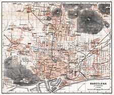 Barcelona historical map from 1913 (Wagner & Debes) Vintage Print Poster
-
$580.23 CAD
 School Wall Map Scandinavia Russia 190x179 ~ 1910 Vintage North East Europe Map
-
$211.86 CAD
 Rollable Wall Chart Vintage Mural Map First World War 1914-1918
-
$46.47 CAD
 LARGE HISTORICAL 1912 KNICKERBOCKER BEER NEW YORK CITY BIRD'S EYE VIEW WALL MAP
-
$305.38 CAD
 School Wall Map Old Germany Card 18.Jhd. 198x199cm ~ 1910 Gaebler
-
$191.36 CAD
 CENTRAL AMERICA MEXICO c. 1910 JOHNSTON LARGE WALL MAP ON LINEN
-
$120.62 CAD
 School Wall Map Beautiful Old World Map 1783-1914 202x133cm Vintage 1970
-
$258.05 CAD
 School Wall Map Old Card Australia German South Seas 219x152 ~ 1915 Map
-
$687.11 CAD
 School Wall Map Northern Europe Scandinavia Scandiavia Vintage 207x208 ~ 1919
-
$2539.44 CAD
 Wall Map Kingdom Prussia Wilhelm II 79 1/2x45 5/16in ~ 1910 Vintage Ull Down Up
-
$43.74 CAD
 Naples historical map from 1911 (Wagner & Debes) Vintage Print Poster
-
$1132.45 CAD
 School Wall Map The War 1870-71 Ein Empire Goes, One Comes 200x130c ~ 1910
-
$30.07 CAD
 VINTAGE PANORAMIC 1912 KNICKERBOCKER BEER NEW YORK CITY BIRD'S EYE VIEW WALL MAP
-
$369.77 CAD
 School Wall Map Beautiful Old Mitteleuropakarte 1914 To 1967 81 1/2x78 11/16in
-
$136.67 CAD
 ANTIQUE PLAT MAP TAYLOR COUNTY WISCONSIN 32" X 32" 1916 ORIGINAL OLD ADS MEDFORD
-
$1093.48 CAD
 1917 Marion County Kansas Platt Map Ownership by section. Original!! 49 x 37
-
$125.75 CAD
 GIANT HISTORICAL 1912 KNICKERBOCKER BEER NEW YORK CITY BIRD'S EYE VIEW WALL MAP
-
$336.23 CAD
 History World Map 1783 – 1914 Rollable Wall Chart Poster
-
$90.21 CAD
 Hamburg City Map from 1912 Vintage Print Poster (Carly's, Oscar Enoch)
-
$164.02 CAD
 ANTIQUE ORIGINAL NORTH AMERICA MAP 1913 RARE -W&AK JOHNSTON- SPECIAL PRICING!
-
$295.23 CAD
 history rollable world map vintage wall chart First World War 1914-1948
-
$32.75 CAD
 Iowa Wright County Map Wall Lake Township 1912 K12#21


