-

$45.01 CAD
 1898 Mediterranean Countries Vintage Geographical Map ORIGINAL 19 x 9.5" C12-6
-
$184.60 CAD
 Antique Map-STEENWIJK-OVERIJSSEL-NETHERLANDS-Kuyper-Kuijper-1865
-
$109.42 CAD
 1911 ATLAS COVER PAGE of WESTCHESTER COUNTY NEW YORK FROM ATLAS SURVEYS 22"x 17"
-
$191.44 CAD
 Antique Map-NETHERLANDS-TOWN PLAN-OLDENZAAL STAD-OVERIJSSEL-Kuyper-Kuijper-1865
-
$21.89 CAD
 Map Vignemale Southern France Rare 1914 Lithograph WW1 Topo Mini DWAA20B
-
$23.26 CAD
 GIBRALTAR GREAT BRITAIN Spain Original Map 1911
-
$20.52 CAD
 Vintage Map of England & Wales 1660-1892 by Longmans Green 1914. Antique
-
$33.51 CAD
 1914 Plat Map Village of Riverton Sangamon County Illinois Clear Lake Township
-
$33.51 CAD
 1914 Plat Map Cotton Hill Township Sangamon County Illinois USGS Soil Map Rare
-
$13.61 CAD
 1912 Original Map Arizona (Year of Statehood Feb. 14, 1912) and on reverse CA
-
$34.19 CAD
 1911 USGS Topo Map DAWSON SPRINGS DANIEL BOONE Kentucky Tradewater River Ilsley
-
$10.88 CAD
 1912 Original Antique Hammond Map Texas and on reverse Oklahoma
-
$31.45 CAD
 1913 USGS Topo Map DRAKESBORO GREENVILLE Kentucky Schools Railroads Elk Valley
-
$34.20 CAD
 SAN FRANCISCO 1912 September dated ORIGINAL plan map USA California
-
$68.38 CAD
 Map Le Mont Dore Southern France Rare 1914 Lithograph WW1 Era WHBS
-
$20.52 CAD
 PRAHA PRAGUE 1910 Original map city plan Cechy Czechia Czech Republic
-
$19.84 CAD
 1912 Plat Map Holst Township Clearwater County Minnesota Lake peterson
-
$8.21 CAD
 Map: Missouri - 1910 county boundaries, railways, cities, St. Louis inset - B&W
-
$27.29 CAD
 CENTURY ATLAS MAP PLATE #18 OHIO SOUTHERN CINCINNATI CLEVELAND 1911 ANTIQUE ORIG
-
$30.09 CAD
 1910 Ohio Highway Road Map Hocking County Logan Carbon Hill Rockbridge Gore OH
-
$27.29 CAD
 CENTURY ATLAS MAP PLATE #32 "KANSAS" WICHITA KANSAS CITY MIDWEST 1911 ANTIQUE KS
-
$177.82 CAD
 THE FARMER ATLAS AND FARMERS DIRECTORY LAC QUI PARLE COUNTY MINNESOTA 1929
-
$27.29 CAD
 ANTIQUE ATLAS MAP PLATE #38 "GEORGIA" SAVANNAH ATLANTA CHICKAMAUGA TYBEE 1911 GA
-
$17.71 CAD
 1911 Antique Rand McNally Map of OHIO w/copy History/Demographics
-
$61.56 CAD
 1893/1917 CRATER LAKE ASHLAND MEDFORD 60min TOPO MAP 16x20" USGS antique OREGON
-
$10.88 CAD
 1911 Original Antique Hammond Atlas Map of Mexico on reverse The West Indies
-
$27.36 CAD
 PALESTINE-JUDAICA old Rare City Map JERUSALEM by Details 1910s
-
$17.71 CAD
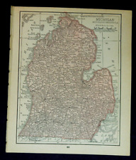 1911 Antique Rand McNally Map of SOUTHERN MICHIGAN w/copy History/Demographics
-
$82.06 CAD
 Map Matigny Ville Southern France Rare 1914 Lithograph WW1 Era WHBS
-
$54.70 CAD
 Map Biarritz Southern France Rare 1914 Lithograph WW1 Era WHBS
-
$449.48 CAD
 1916 Thomas Hewitt Large Folding Antique Map of Southern Tasmania w/ Hobart
-
$68.38 CAD
 Map Cantal And Dore Mountains Southern France Rare 1914 Lithograph WW1 Era WHBS
-
$8.89 CAD
 Map: Vermont & New Hampshire - 1910 county boundaries, railways, cities - sepia
-
$13.61 CAD
 1914 Original Hammond Map: Spain (w/list of Provinces) & Portugal on rev. Italy
-
$19.84 CAD
 1912 Plat Map Part of White Earth Indian Reservation Clearwater County Minnesota
-
$17.10 CAD
 1914 Plat Map City of Springfield & Environs Illinois Jefferson & Washington
-
$41.02 CAD
 1913 Map CENTRAL AMERICA CARIBBEAN Panama Canal Steamship Route Coaling Stations
-
$23.26 CAD
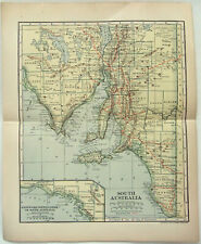 Original 1910 Map of South Australia by Dodd Mead & Company. Antique
-
$54.72 CAD
 Map Bordeaux Southern France Rare 1914 Lithograph WW1 Era WHBS
-
$34.06 CAD
 1912 FRANCE Vintage Map Paris Mediterranean Sea ORIGINAL 11.5 x 9.5 Color C10-8
-
$34.06 CAD
 1912 FRANCE Vintage Map Paris Mediterranean Sea ORIGINAL 11.5 x 9.5 Color C12-4
-
$27.36 CAD
 1912 Type Map of Lille, France
-
$13.67 CAD
 CENTURY ATLAS MAP PAGE PLATE NO.14 STATE OF NEW JERSEY 1911 VINTAGE
-
$13.53 CAD
 CENTURY ATLAS MAP PAGE PLATE NO.92 ITALY 1911 VINTAGE
-
$17.71 CAD
 1915 Original Map of Austria-Hungary and on reverse Switzerland
-
$38.23 CAD
 CENTURY ATLAS MAP PLATE #56 CALIFORNIA SAN FRANSISCO YOSEMITE ANTIQUE 1911 CA SF
-
$14.86 CAD
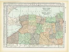 1910 Color County Map of Western & Upstate Section New York State
-
$19.84 CAD
 1912 Plat Map Bear Creek Township Clearwater County Minnesota Alida
-
$19.84 CAD
 1912 Plat Map Part of Red Lake Indian Reservation Clearwater County MN 150N 36W
-
$17.71 CAD
 1911 Antique Rand McNally Map of CONNECTICUT & RHODE ISLAND & State Demographics
-
$19.84 CAD
 1912 Plat Map Hangaard Township Clearwater County Minnesota Red Lake Indian Res
-
$17.71 CAD
 1911 Antique Rand McNally Map of FLORIDA w/copy History/Demographics
-
$54.72 CAD
 Beautiful Map-SWITZERLAND 1911 -SCHWEIZ-SUISSE Muir Way New Topographical
-
$27.29 CAD
 CENTURY ATLAS MAP PLATE #58 "ALASKA" ANCHORAGE ALEUTIAN ISLANDS ANTIQUE 1911 AK
-
$13.61 CAD
 1911 Original Hammond Map: Alaska Terr. on rev. Washington w/Ind. Reservations
-
$82.06 CAD
 1917 World War I Large Scale Cloth Folding Color Map Western & Italian Front
-
$41.02 CAD
 Original 1913 Large-Format Map PANAMA Colón Penonome David Chepo Canal Profile
-
$109.42 CAD
 Antique Mexican MINI ATLAS DE LA REPUBLICA MEXICANA Geographic Maps from 1910s
-
$102.60 CAD
 1906 FLATHEAD RIVER KINTLA LAKES 30min USGS TOPO MAP 16x20" antique MONTANA
-
$19.84 CAD
 1912 Plat Map State Park Clearwater County Minnesota Lake Itasca Elk Lake
-
$205.12 CAD
 Large RARE 1910 Official Map Of New York State - The National Survey Co. (#513)
-
$24.62 CAD
 New Zealand - North Island - Original 1910 Map by Dodd Mead & Company. Antique
-
$17.10 CAD
 1914 Plat Map City of Springfield & Environs Illinois Capitol Building Orendorff
-
$17.10 CAD
 1914 Plat Map City of Springfield & Environs Illinois John C. Cook Loose
-
$19.84 CAD
 1912 Plat Map Town of Leonard Murray Ebro Clearwater County Minnesota
-
$13.68 CAD
 1910. SOUTH AMERICA. VENEZUELA. ECUADOR. COLOMBIA. PERU etc. Antique map.
-
$13.53 CAD
 CENTURY ATLAS MAP PAGE PLATE NO. 114 OCEANICA PACIFIC OCEAN 1911 VINTAGE
-
$12.80 CAD
 GERMANY ULM Town Plan Good for Genealogy Research - 1910 MAP Baedeker
-
$13.53 CAD
 CENTURY ATLAS MAP PAGE PLATE NO.98 TURKEY IN EUROPE BALKANS 1911 VINTAGE
-
$19.84 CAD
 1912 Plat Map Copley Township Clearwater County Minnesota Bagley Red Lake Road
-
$21.89 CAD
 Map Bagneres De Luchon Southern France Rare 1914 Lithograph WW1 Street DWAA20A
-
$19.84 CAD
 1912 Plat Map Pine Lake Township Clearwater County Minnesota Gonvick
-
$27.29 CAD
 CENTURY ATLAS MAP 3 "NORTH POLE" UNEXPLORED ARCTIC OCEAN GREENLAND 1911 ANTIQUE
-
$19.84 CAD
 1912 Plat Map Eddy Township Clearwater County Minnesota 148N 38W
-
$17.10 CAD
 1914 Plat Map City of Springfield & Environs Illinois NE Jones & Adams Coal Co.
-
$42.46 CAD
 EGYPT Cairo City Town Plan - 1911 MAP 13 x 15.5" (33 x 39 cm)
-
$17.71 CAD
 1911 Antique Rand McNally Map of UPPER MICHIGAN w/copy History/Demographics
-
$23.26 CAD
 South Australia - Original 1910 Map by Dodd Mead & Company. Antique
-
$19.84 CAD
 1912 Plat Map Greenwood Township Clearwater County Minnesota Red Lake Indian res
-
$17.10 CAD
 1914 Plat Map City of Springfield & Environs Illinois Wanless Capital Heights
-
$19.84 CAD
 1912 Plat Map Part of White Earth Indian Reservation Clearwater County Minnesota
-
$32.82 CAD
 1911 Stieler Map - Australia Victoria New South Wales Sydney Melbourne Adelaide
-
$17.10 CAD
 1914 Plat Map City of Springfield & Environs Illinois Iles Park Stuart School
-
$27.29 CAD
 CENTURY ATLAS MAP PLATE #41 TENNESSEE CHATTANOOGA NASHVILLE ORIG ANTIQUE 1911 TN
-
$17.71 CAD
 1911 Antique Rand McNally Map of UTAH w/copy History/Demographics
-
$19.84 CAD
 1912 Plat Map City of Bagley County Seat Clearwater County Minnesota
-
$19.84 CAD
 1912 Plat Map Minerva Township Clearwater County Minnesota Upper Rice Lake
-
$19.84 CAD
 1912 Plat Map Sinclair Township Clearwater County Minnesota 149N 36W
-
$27.29 CAD
 CENTURY ATLAS MAP PLATE #37 "SOUTH CAROLINA" CHARLESTON 1911 ANTIQUE OLD SC
-
$12.80 CAD
 GERMANY Pyrmont Hameln Town Plan - 1912 MAP 4 x 6" (10 x 15,5 cm)
-
$21.87 CAD
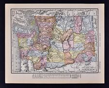 1911 McNally Index Map - Washington - Seattle Spokane Olympia Tacoma Mt. Rainer
-
$62.86 CAD
 1916 Plat Map ~ LEE COUNTY, IOWA ~ Authentic Atlas Map ~ (14x17) Free S&H -#001
-
$32.83 CAD
 Denver, CO - Original 1910 Dated City Map by Dodd Mead & Company. Antique
-
$61.56 CAD
 1894/1910 KLAMATH LAKE LINKVILLE 60 min TOPO MAP 16x20" USGS antique OREGON
-
$19.84 CAD
 1912 Map Northern Portion of Clearwater County Minnesota Red Lake Indian Reserve
-
$13.53 CAD
 CENTURY ATLAS MAP PAGE PLATE NO. 6 MEXICO 1911 VINTAGE
-
$136.79 CAD
 China Map 1913 (13 x 16); Treaty Ports, Hong Kong, Shanghai; Drawn for Crow's
-
$19.84 CAD
 1912 Plat Map Part of White Earth Indian Res Clearwater County Minnesota
-
$34.06 CAD
 1915 FRANCE Vintage Map Paris Mediterranean Sea ORIGINAL 11.5 x 9.5 Color C10-9
-
$273.58 CAD
 Trott 1912 Large MAP Railway System INDIA Burma Ceylon. 30in x 30in


