
-
$83.66 CAD

 1852 Antique Military Map British Forts & Positions, 8th Xhosa War South Africa
-
$61.09 CAD
 1872 Map of KENTUCKY & TENNESSEE, Hand Colored
-
$21.83 CAD
 Antique 1837 SOUTH WESTERN DISTRICT LOUISIANA MAP, Sabine & Red Rivers, Color
-
$198.35 CAD
 original 1899 USGS map Dennisville Anglesea Stone Harbor, Cape May Courthouse NJ
-
$40.69 CAD
 c.1836 Bas-Alpes, Alpes-de-Haute-Provence, Antique Card Map by Bourrut-Le Meri
-
$307.79 CAD
 1843 Rare Original Map of United States, Mexico and Cuba
-
$307.79 CAD
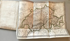 Rare 1819 BARBIE DU BOCAGE Antique Book w/ 32 Copper Engraved Maps Plans Plates
-
$170.98 CAD
 1850 Guysborough Harbour Nova Scotia Antique Sea Coastal Map NS Canada (1859)
-
$20.51 CAD
 Antique 19th Century French Swiss Map France Switzerland Prussia Europe 7" x 5¼"
-
$39.56 CAD
 FRANCE In The Year 1570 To Illustrate St. Bartholomew Eve MAP Normandy Champagne
-
$33.98 CAD
 1838 MAP - ITALY Piedmont France Savoy Land of Neff 13.5 x 16.6" 34 x 42 cm
-
$34.13 CAD
 1898 Watkins Glen NY Seneca Lake New York USGS Topographic Map Vintage Schuyler
-
$9917.64 CAD
 Original 1848 Blunt Blueback Nautical Chart US East Coast Block Island to Cuba
-
$50.19 CAD
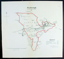 1832 Robert Kearsley Dawson Antique Map City of Marlborough Wiltshire, England
-
$102.60 CAD
 1840 Antique South America Map Amazon Peru Bolivia Brazil Andes SDUK London
-
$65.66 CAD
 Antique 1805 Hand Colored Engraving Map of Westmoreland England by John Cary
-
$68.40 CAD
 1824 Antique Map; Scotland by Anthony Finley
-
$98.49 CAD
 RUSSIAN AMERICA ALASKA UNITED STATES CANADA 1846 MALTE-BRUN UNUSUAL ANTIQUE MAP
-
$20.51 CAD
 Antique 19th Century Hand Colored African Bookplate Print Map of Africa 1857
-
$57.45 CAD
 Antique Map - South London in 1813
-
$88.92 CAD
 Map of Hindoostan (India) by Aaron Arrowsmith Sidney Hall 1817 Handcolored
-
$170.98 CAD
 1857 Beaver Harbour Nova Scotia Antique Sea Coastal Map Atlantic Canada (1859)
-
$67.03 CAD
 1863 Johnson's PALESTINE Antique Map Hand Colored 14 x 18"
-
$34.02 CAD
 IRELAND Southern Part - c. 1835 Original Map 11 x 16"
-
$67.03 CAD
 1863 Johnson's Map of Maryland and Delaware District of Columbia 14 x 18"
-
$102.60 CAD
 Map of Orkney Shetland Scilly Channel Islands Arrowsmith Hall 1817 Handcolored
-
$32.83 CAD
 Northern Egypt Russian Map 1844
-
$98.49 CAD
 Der Hauptpass durch den Balkan Antique Map Engraving Mountain Massif Veduta 1840
-
$65.66 CAD
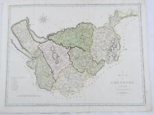 Antique 1805 Hand Colored Engraving Map of Cheshire England by John Cary
-
$51.98 CAD
 CAPTAIN LYON / FINDEN c1823 Engraving Eskimo of Igloolik Takkelikketa Sxcarce
-
$42.58 CAD
 1847 Vuillemin Antique Map The Turkish Empire in Europe from Greece to Austria
-
$1641.54 CAD
 Original Antique Africa Maps Rare Early 1800s Fine Engraved Large 4 Sheet Map
-
$41.02 CAD
 Original 1841 FOX HUNTING Map "Meets of the Petchley Hounds" Northampton England
-
$1287.27 CAD
 BEAUTIFUL COLOUR FRENCH ANTIQUE 1856 HAND WATERCOLOUR MAP OF DEPT DES LA CORSE
-
$102.60 CAD
 1898 map of Elmira, Horseheads, E. Corning, NY USGS original antique RARE
-
$42.58 CAD
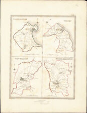 1835 Walker Antique Map Scarborough Whitby New Malton North Allerton, Yorkshire
-
$170.98 CAD
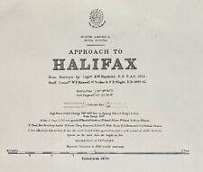 1853 Halifax Nova Scotia Antique Sea Coastal Map Atlantic Canada (1854)
-
$82.08 CAD
 Antique 1865 Bible Map Engravings Canaan Jerusalem Travels of Jesus and St. Paul
-
$135.43 CAD
 1863 JOHNSON'S ROMAN EMPIRE,IMPERIUM ROMANORUM LATISSIME PATENS 18 x 26"
-
$94.39 CAD
 1863 Johnson's MASSACHUSETTS CONNECTICUT and RHODE ISLAND 18" x 26"
-
$34.46 CAD
 GERMANY Northern Part & East Poland - c. 1835 Original Map 11 x 16"
-
$259.90 CAD
 Original 1855 Colton's Map of Alabama Taken from Atlas
-
$191.51 CAD
 USGS TOPOGRAPHIC MAP - GRANVILLE, MASSACHUSETTS / CONNECTICUT
-
$50.19 CAD
 1845 John Dower Antique Map of South America
-
$20.51 CAD
 Antique 19th Century European Bookplate Map Europe Parleys Book of History 1849
-
$34.46 CAD
 GERMANY Southern Part - c. 1835 Original Map 11 x 16"
-
$20.51 CAD
 Antique 19th Century Map Print Netherlands Belgium Flanders 1849 Europe 7" x 5¼"
-
$129.96 CAD
 USGS TOPOGRAPHIC MAP - CARMEL. NEW YORK/CONNECTICUT
-
$123.12 CAD
 USGS TOPOGRAPHIC MAP - CANAJOHARIE, NEW YORK
-
$129.96 CAD
 1838 Russia EAST SIBERIA Map of Communication Roads IRKUTSK & TRANS-BAIKAL Area
-
$164.15 CAD
 Rare 1897 Colorado map Tenmile District, now ghost towns NE of Leadville, CO
-
$191.51 CAD
 USGS TOPOGRAPHIC MAP - FRANKLIN, MASS - RI
-
$41.02 CAD
 c 1836 Russia in Europe by J. Dower / Orr - 11.2" x 9.1" authentic antique map
-
$61.56 CAD
 1827 Europe in 12 Sheets # 6 Russia by J. Mawman - 16.8" x 10.6" authentic map
-
$191.51 CAD
 USGS TOPOGRAPHIC MAP - PALMER, MASSACHUSETTS / CONNECTICUT
-
$205.19 CAD
 USGS TOPOGRAPHIC MAP - WORCESTER, MASSACHUSETTS
-
$136.78 CAD
 Niagara Falls New York Antique Topographic Map 1800s Survey By Blackwell
-
$205.18 CAD
 Original 1855 Colton's Map of Canada Maritimes Taken from Atlas
-
$35.48 CAD
 Antique County Map of KENTUCKY & TENNESSEE (Virginia & West Virginia on Back)
-
$239.39 CAD
 original 1898 map of Castle Rock, Larkspur, Monument, Eastonville, Elizabeth, CO
-
$99.99 CAD
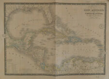 BRUÉ Map of Caribbean Carte des Isles Antilles des Etats Unis de L'Amérique 1860
-
$1573.13 CAD
 1836 South Atlantic Sea Voyage with Tracks Positions Elevations Drawn on Map
-
$1287.27 CAD
 FINE ANTIQUE 1856 HAND WATERCOLOUR MAP OF DEPT DES HAUTES ALPES BY LEVASSEUR'S
-
$19.49 CAD
 c.1810 Map of Poland and Prussian States Andrew Bell Encyclopedia Britannica
-
$6422.22 CAD
 1813 Joh. W. Von Goethe & Alex. Von Humboldt; Comparative view of Mountains - Ea
-
$13.61 CAD
 Newsweek Map of the Month August 1966 "The Legacy of Crisis" 35" x 44"
-
$102.60 CAD
 1899 map of Olean, NY & Cuba RARE antique original
-
$164.15 CAD
 USGS TOPOGRAPHIC MAP - WEBSTER, MA, CT, RI
-
$184.67 CAD
 USGS TOPOGRAPHIC MAP - BARRE, MASSACHUSETTS
-
$65.66 CAD
 1837 Virgin Islands Map Engraving Southward To Tortola By W Hooker
-
$303.26 CAD
 Archipel de Mendana, Marquesas Islands Van der Maelen 1827
-
$150.47 CAD
 USGS TOPOGRAPHIC MAP - FONDA, NEW YORK
-
$42.58 CAD
 1835 Walker Antique Map Carlisle, Whitehaven, Cockermouth in Cumberland England
-
$752.36 CAD
 Original 1831 Friesz Nautical Map GUADELOUPE Marie-Galante Desirade Caribbean
-
$116.28 CAD
 1896 THIRTEENTH LAKE New York Antique USGS Topographic Map ADIRONDACK ORIGINAL
-
$102.60 CAD
 2x 1832 Antique Map Austrian Dominions J & C Walker Hungary Transylvania Bohemia
-
$785.89 CAD
 2 Antique Prints-MAP-SOUTH AMERICA-TWO SHEETS-Cary-1811
-
$136.79 CAD
 original 1899 USGS map of Rico Quadrangle, CO San Juan Range antique topographic
-
$218.86 CAD
 Original 1843 Wyld Map RUSSIA IN EUROPE Moscow Kiev Minsk Crimea South Post Road
-
$957.56 CAD
 Bay of Cattaro Kotor Nautical Map of Port Montenegro Italy Serbia Yugoslavia
-
$164.15 CAD
 USGS original map 1899 Mystic, Connecticut Westerly, R.I. Fisher’s Island, N.Y.
-
$136.79 CAD
 original 1903 USGS of Mt. Ida, AR & Fourche Fave River
-
$1287.27 CAD
 FINE FRENCH ANTIQUE 1856 HAND WATERCOLOUR MAP OF DEPT DES HAUTES PYRENEES
-
$136.79 CAD
 original 1898 USGS map of Haverhill, MA, Kingston, Brentwood, Hampstead, RI topo
-
$121.75 CAD
 1863 Johnson's EUROPE by Johnson and Ward hand colored 18" x 26"
-
$116.28 CAD
 original 1898 USGS map south of Baltimore to Crownsville and Crofton
-
$95.74 CAD
 Newsweek Map of the Month August 1967 43x34
-
$136.79 CAD
 original 1897 USGS map Elmoro, Trinidad, Gray Creek, Earl, Las Animas Co., CO
-
$198.35 CAD
 Original 1897 USGS map of Lawrence, Wakefield, Groveland, MIddleton, MA topo
-
$136.79 CAD
 original 1894 USGS map of Independence, Blue Springs Excelsior Liberty MO
-
$116.28 CAD
 original 1898 USGS map of Greenfield, Shelburne Falls, Conway, Burkville, MA
-
$75.24 CAD
 Map of The Country Northwest of Boston 1896 ORIGINAL by The Appalachian Club
-
$129.96 CAD
 Original 1898 USGS map of Winchendon, Athol, Templeton, MA Howeville, NH topo
-
$376.19 CAD
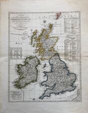 1804 Map: the United Kingdom of Great Britain and Ireland, by I. G. L. Weidner.
-
$129.96 CAD
 OrIginal 1898 USGS map of Fitchburg, Gardner, Ashburnham, , Ashby, MA topo
-
$129.96 CAD
 Original 1898 USGS map Warwick, Orange, Northfield, Miller Falls, MA, NH, VT
-
$51.98 CAD
 1863 JOHNSON'S BRAZIL ARGENTINE REPUBLIC,PARAGUAY AND URUGUAY hand col 14" x 18"
-
$94.39 CAD
 1863 Johnson's PRUSSIA NORWAY SWEDEN and DENMARK Hand Colored 18" x 26"
-
$94.39 CAD
 1862 Johnson Map of Austria, Turkey in Europe and Greece Hand Colored 18" x 26"
-
$53.35 CAD
 1863 Johnson Map of NEW HAMPSHIRE VERMONT by Johnson Ward 18" x 26"


