 Antiques (CA)
Africa Maps
Asia Maps
Australia/Oceania Maps
Celestial Maps
Central America/Caribbean Maps
Curiosities Maps
Digital Maps
Europe Maps
Map & Globe Mixed Lots
Map & Globe Reproductions
North America Maps
South America Maps
World & Celestial Globes
World Maps

-
$61.51 CAD

 1750 Hand-Colored Map of Europe by Robert De Vaugondy
-
$293.87 CAD
 Antique Map - 1770 Original Map of North America by Thomas Bowen
-
$94.31 CAD
 Original Antique 1780 Map of Europe by Bonne
-
$273.36 CAD
 American Revolution 1775-1783 Atlas 18th Century Maps Charts Set of 20
-
$80.64 CAD
 Historic Map Groton Conn 1655-1799 Town Owner Names Genealogy Date Unknown
-
$68.34 CAD
 Antique maps, Bonne, Le nord de l'Europe .. Danemark, La Norwege, la Suede 1780
-
$205.03 CAD
 1787 Rigobert Bonne Mappemonde Occidental Western Hemisphere Antique Map
-
$121.70 CAD
 1756 d’ Anville map of the coast of Peru by Bellin, including Lima
-
$155.67 CAD
 1758 Map, “Rade et Ville de la Vera-Cruz, vera Cruz, Mexico, by Schley
-
$273.37 CAD
 2 America Island Maps by Jean Baptist Anville Circa 1730 Hispaniola Mexican Gulf
-
$1076.39 CAD
 Antique "Map of the British and French Settlements in North America" 1755
-
$410.06 CAD
 1740's ORIGINAL MEXICO NEW HISPANIA MAP
-
$95.61 CAD
 1746 Map of Hertfordshire England - Thomas Kitchin - Hartfordshire - Temperance
-
$263.12 CAD
 1719 H. Chatelain Large Antique Print City Views Algiers, Jijel, Tripoli & Tunis
-
$203.94 CAD
 OLD COLOURED MAP - MAJORCA -SPAIN -1760 - GEOGRAPHER T.C. LOTTER - 22 X 17 1/2
-
$635.65 CAD
 Antique Map Of The Malabar Coast By Baldaeus (1744) Canara Decan Old Collectible
-
$12.30 CAD
 Map 1930 The West Transylvania c1763-77 5.5 x 9" Europe History Ephemera DWEE2
-
$188.63 CAD
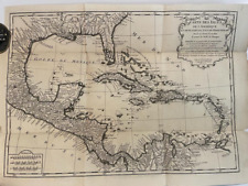
 1799 Rare Map Gulf of Mexico, Florida, West Indies, Pierre Bertholon
-
$68.34 CAD
 maps, Bonne, Carte de la Hollande / sept provinces unies des Pays Bas 1780
-
$18.45 CAD
 Map Revolutionary War South Colonies 1871 Victorian Woodcut Print History DWAA12
-
$61.51 CAD
 Carte Des Pays D'Amerique SEPTENTRIONALE Dresses en 1778 (20th Century Litho)
-
$403.22 CAD
 Antique Prussia Germany Map Jan Kool Watermark Late 18th/Early 19th Century
-
$129.85 CAD
 Map "Cartes Particulieres des Isles de France, de Bourbon et de Rodrigue" 1780
-
$54.67 CAD
 Oyster and Huntington Bays 1778 Published by an Act of Parliament Repro.
-
$88.85 CAD
 LATE 18TH MAP OF ENGLAND'S NORTH RIDING & YORKSHIRE BY EMAN BOWEN
-
$24.60 CAD
 Map Sherman's Army Virginia Operations 1871 Victorian Lithograph History DWAA12
-
$213.68 CAD
 1763 Map of Indonesia, Semarang, Kartasoera, Soerabaya by Schley
-
$395.02 CAD
 Scarce & Large 1747 Le Rouge French Hand Colored Map of Europe
-
$273.37 CAD
 Ancient Maps of the "Holy Land" dated 1535-1585, 1586, 1533-1585, and 1710
-
$247.87 CAD
 A very rare map of NW America (SW Alaska) by Hogg 1784 Showing J. Cook's travels
-
$635.65 CAD
 Antique Map Regionum Choromandel, Golconda Et Orixa Nova Et Accurate Descriptio
-
$273.37 CAD
 Italy Italia c.1770 Isaak Tirion rare folio sheet antique map not in Borri
-
$102.51 CAD
 Plan of The City Of New York Map-Surveyed 1782-1785/Read All Details
-
$21.93 CAD
 Ballinasloe Roscommon antique road map Ireland c1782 Taylor & Skinner 235/236
-
$2732.33 CAD
 Antique Andreas Cellarius Celestial Ptolemaic World Map Zodiac 18th Century
-
$66.98 CAD
 Carte du Golfe d'Arabie: depuis Suez à Bab-El-Mandeb 1791 Bernard
-
$539.91 CAD
 1706 Original Daniel de la Feuille map of Italy and Cities Very Scarce Map
-
$75.18 CAD
 1780 Ancient Map of Russia
-
$116.18 CAD
 Vintage framed Map and illustrations of Derbyshire England colored
-
$120.27 CAD
 1760 Jean de Beaurain Antique Map Battle of Lauffeldt, Belgium, Austrian War
-
$1366.85 CAD
 Engraving RHEINFELDEN, 1737. , Andreas and Joseph Schmuzer , Austria , Habsburg
-
$205.03 CAD
 Generalis Lotharingae Ducatus Tabula By Nicolaum Visscher Amst
-
$34.17 CAD
 MAP: HINDOSTAN OR INDIA ~ c1797-1805 ~ THOMAS & ANDREWS PUB. ~ GRIDLEY ENGRAVED
-
$1090.75 CAD
 1795 Rare antique map of Pennsylvania based on Reading Howell's Map Samuel Lewis
-
$205.01 CAD
 Emmanuel Bowen H Overton Map of Nottingham 1760 RARE Engraving Framed 22" Map
-
$68.34 CAD
 Antique maps, Bonne, Les royaumes d'Espagne et de Portugal 1780 Spain
-
$129.85 CAD
 Large 1794 Map of Portugal by la Calcograria Camerale Rome 1st Folio Leon Region
-
$21.93 CAD
 Antrim Down antique road map C1782 Northern Ireland Taylor & Skinner map 281/282
-
$177.69 CAD
 Map of Holland, Circa 1730
-
$246.03 CAD
 Russian Empire European Holdings Finland Ukraine Crimea c. 1790's two sheet map
-
$239.20 CAD
 Antique 1787 French Maritime Hydrography Map Eastern Coast United States M Bonne
-
$266.54 CAD
 ANTIQUE COPPER ENGRAVED MAP 18th Century France Military J.B. Nolin French
-
$375.88 CAD
 ORIG. NAUTICAL CHART - COASTS OF ENGLAND, FLANDERS & HOLLAND -MOUNT & PAGE -1750
-
$1195.99 CAD
 RARE 1794 Early Map of South Carolina by Stockdale, Morse, American Geography SC
-
$358.29 CAD
 1780 Basel, Bale, Basel, Switzerland, Large copper engraving of the City
-
$296.96 CAD
 Friendly Islands Débarquement à Middelburgh James Cook 1778
-
$136.67 CAD
 Russia Moscovy Finland 1725? Moll ORIGINAL map Ukraine Lapland Crimea EXCELLENT
-
$38.27 CAD
 Map Of Baltimore Town. Print On Smooth Paper.
-
$135.32 CAD
 1723 Russia OCHAKOV Battle on Prut TURKISH-RUSSIAN War 1711 Orig. Engraving MAP
-
$176.32 CAD
 Map of Campaigns of Charles XII, King of Sweden, Poland Russia Germany 1721
-
$682.06 CAD
 CHINA MAP Circa 1780 - 1806 - Empire of China by De Laporte FREE SHIPPING
-
$12.30 CAD
 Map 1930 U.S. Colonies In 1760 5.5 x 9" Settlement History Ephemera DWEE2
-
$51.94 CAD
 CAPTAIN LYON / FINDEN c1823 Engraving Eskimo of Igloolik Takkelikketa Sxcarce
-
$222.39 CAD
 Terre de Kerguelen, Voyage Cook old map, Bonne 1788
-
$12.30 CAD
 Map 1942 U.S. Colonies In 1760 5.5 x 9" Settlement History Ephemera DWW6B
-
$116.18 CAD
 OGILVY & BOWEN c1736 Original Map of Oxfordshire Berkshire Etc.
-
$302.07 CAD
 Holland Amsterdam Nederland Netherlands Antique Map Johann Baptist Homann 1733
-
$150.35 CAD
 1725 Framed Engraving Madagascar -"Voyages de la Compagnie Des Indes Orientales"
-
$205.03 CAD
 Large Russian Empire map. 1787. By Tardieu.
-
$12.30 CAD
 Map 1930 Caribbean Sea In Colonial Era 5.5 x 9" World History Ephemera DWEE2
-
$58.77 CAD
 Original Antique 18th C Map of Poland/Lithuania
-
$265.70 CAD
 1780 Bonne - Antique Map Carte Des Isles Canaries Canary Islands - Handcoloured
-
$384.44 CAD
 Tahiti Matavai Bay sailing canoes Old print Cook voyages 1778
-
$249.71 CAD
 Tahiti Queen Purea Surrender to Capt Wallis Hawkesworth 1778
-
$12.30 CAD
 Map 1942 Caribbean Sea In Colonial Era 5.5 x 9" World History Ephemera DWW6B
-
$615.08 CAD
 014 Antique Original 1711 map of Crimea, Ukraine, Poland Turkey RARE!!!
-
$21.93 CAD
 Ballynahinch Dromore antique road map Northern Ireland C1782 map 283/284
-
$539.91 CAD
 1706 Original Daniel de la Feuille map of Europe Very Scarce Map
-
$6417.06 CAD
 1813 Joh. W. Von Goethe & Alex. Von Humboldt; Comparative view of Mountains - Ea
-
$29.03 CAD
 18th C Map of the Migrations of the Celts Gomer-Cimmerians & Scythians People
-
$21.93 CAD
 Derry Colerain Northern Ireland antique road map C1782 Taylor & Skinner 271/272
-
$135.32 CAD
 ASIA 1787 ORIGINAL ANTIQUE COPPER ENGRAVING MAP BONNE
-
$410.06 CAD
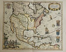
 1794 "A New Map of North America" - Gorgeous Antique Map
-
$403.22 CAD
 c.1700 Wells New Map of the North Part of Antient Africa Duke of Gloucester
-
$12.30 CAD
 Map 1942 Territorial Growth Of United States 5.5 x 9" History Ephemera DWW6B
-
$21.93 CAD
 Sligo Westport Ireland antique road map C1782 Taylor & Skinner 223/224
-
$66.98 CAD
 EGYPT 1787 AFRICA ORIGINAL ANTIQUE COPPER ENGRAVING MAP BONNE
-
$274.12 CAD
 1730c GERMANY Bavaria, Salzburg, Bohemia - 44 cm map with cartouche
-
$249.71 CAD
 Queen Charlotte Island, James Cook voyages, old map by Bonne 1787
-
$61.51 CAD
 Vintage DAC Old World Maps (1570-1750) Lithograph Set of 3 Donald Art NY 11 x 14
-
$1640.22 CAD
 Johann Friedrich Probst “BERLIN”. Copper engraving, coloured, Augsburg 1755-68
-
$375.88 CAD
 021 Antique Original 1776 city view of Lemberg, Lwow, Lviv, Ukraine Poland RARE!
-
$129.85 CAD
 1779 Switzerland Engraved Map by Robert de Vaugondy (MBP57)
-
$12.30 CAD
 Map 1942 State Claims Western Lands c1783-1802 5.5 x 9" History Ephemera DWW6B
-
$21.93 CAD
 Lanesborough Ballymahon Strokestown Ireland antique coach road C 1782 map 67/68
-
$2665.36 CAD
 1766 English Colonial Map of India Seur Bellin W. Herbert London Hydrographical
-
$15.38 CAD
 Map 1930 State Claims Western Lands c1783-1802 5.5 x 9" Offset Lithograph DWEE2
-
$21.93 CAD
 Newtown Butler Clogher Northern Ireland antique road map C 1782 no 258 coloured
-
$49.60 CAD
 1795 John Lodge Antique Map of The German Empire
-
$15.38 CAD
 Map 1930 Territorial Growth Of United States 5.5 x 9" History Lithograph DWEE2


